Pokemon Go, Waze, FourSquare; what do they all have in common? They are all driven by Geographic Information System (GIS) and Geospatial Technology. A GIS lets us visualise, question, analyse and interpret data to understand relationships, patterns and trends. Geospatial Technology more broadly refers to electronics used in the visualisation, measurement and analysis of the earth's features, typically involving such systems as the Global Positioning Systems (GPS) and Remote Sensing (RS). It is the science and technology that runs in the background of your mobile Facebook application which allows you to “Check in” when you are at your favourite place or view, in real time, footage of coastlines damages by floods captured remotely using a drone or see 3D images of your home on Google Earth. Many of the world’s most popular applications utilise some aspect of GIS, however there’s more to this discipline than powerful maps, navigation and augmented reality.
GIS benefits organisations of all sizes and disciplines, in both the private and public sector. It is currently widely used to optimise maintenance schedules and daily fleet movements and is the go-to technology for making better decisions about location. Indeed, there are many other uses such as, for example, in Agriculture, where GIS can be used to promote more effective and efficient farming techniques through analysis of soil data to determine what are the best crops to plant and where their seeds can be sown for the greatest yield. GIS can assist Business Development by keeping track of where customers are located, site business, target marketing campaigns, and optimise sales territories and model retail spending patterns.
In the Tourism Industry, GIS can provide a cadre of techniques of far reaching applicability that can aid nations in attaining sustainable tourism developmental goals. In the Health Sector, GIS can provide cost effective tools for evaluating interventions and policies that can control the spread of communicable diseases and improve access to health care by positioning it where it is needed the most. GIS analysis of environmental health data is also powerful in explaining the relationships of disease patterns with the social, institutional, technological built and natural environment. GIS based Digital Taxation systems can assist Governments in solving taxation problems to maximise government income as well as help regulate urban growth and its direction of expansion and to find suitable sites for further urban development. GIS technology can provide the geographic advantage for law enforcement agencies by turning data into actionable knowledge to improve resource allocation, crime analysis and surveillance.
Accurate and comprehensive spatial data is critical to any and all of these application and the benefits to be derived from them. However, Trinidad and Tobago lacks comprehensive, authoritative datasets that can be integrated in a GIS to reap these benefits. To this end, and in commemoration of world GIS Day 2016, The GIS Society of Trinidad and Tobago (GISSTT) is hosting its first Mapathon entitled: Mapathon 2016 “Mapping with Purpose”. The concept of the event is simply to engage the GIS community, both professionals and enthusiasts, in a non-conforming activity. It involves the digitisation of roads and buildings within the Borough of Chaguanas using Land and Surveys 2014 high resolution aerial imagery in order to create authoritative datasets to facilitate informed decision making. It promises to be a successful event and an excellent opportunity for local GIS affiliates to associate themselves with a worthwhile cause. The Mapathon will be held at the Department of Geomatics Engineering and Land Management, the University of the West Indies, St Augustine on November 26, 2016 from 9:00 am to 12:00 pm. Admission is free and all are welcome, however space is limited so we encourage persons to reserve their spots early.
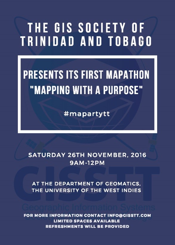
Figure 3: The GISSTT will host its first Mapathon "Mapping with a Purpose” on November 26, 2016 at the DGELM, UWI.
The GISSTT is a non-profit organization founded in 1996. Our mission is to create a platform for Geographic Information Systems in Trinidad and Tobago that inspires, educates and informs in order to realize the full potential of GIS in our country. Our objectives are to promote the use of GIS concepts and technology, to facilitate a medium for exchange of ideas among various interest groups, including GIS users, suppliers, professional organizations, governmental agencies and other interested parties and to develop a body of knowledge toward the effective and efficient use of GIS. For more information on the Society and future events, you can call or email us at 292-9055 / This email address is being protected from spambots. You need JavaScript enabled to view it. or visit our website at www.gisstt.com

Figure 4: The 2016-17 Executive Committee of the GISSTT. From left to right: Avinash Ramcharitar - Treasurer, Ramona Sirju - PRO, Tegan Medina - President, Danika Edghill - Secretary, Juel Paul - Professional Member and Shane Ragbir - Vice President